Share this article
Put it on someone else's radar
Use the quick-share sheet, send it to social, or copy the link for a text or post.
Severe weather moved into eastern Iowa Thursday afternoon as forecasters warned of a tornado threat, damaging wind, and large hail across the region. The National Weather Service’s warning area and local broadcast coverage pointed to a fast-moving, dangerous setup across Washington, Johnson, and Cedar counties as storms organized and pushed northeast.
By midafternoon, the storm that would later pass near West Branch had already produced reports of tornado activity farther southwest. KCII reported that a tornado warning was issued for parts of Washington and Johnson counties, with trained spotters reporting a funnel cloud with possible debris northeast of West Chester at 4:18 p.m. The same outlet reported confirmed tornadoes south of Kalona and again near Hills Access in Johnson County before the storm continued toward Cedar County.
The storm then moved toward West Branch. KWQC’s live weather coverage reported a tornado observed on the ground near West Branch at 4:44 p.m. At 4:52 p.m., KWQC reported that the Cedar County Sheriff’s Office confirmed a tornado on the ground three miles east of West Branch heading toward Tipton. KCRG also reported that the storm cell moving across Washington, Johnson, and Cedar counties carried a tornado warning and large-hail reports.
A rolling storm report log compiled from National Weather Service data recorded a rope tornado on the ground near X40 east of West Branch at 4:44 p.m. The same log also listed large hail and later damage reports in the broader storm path, including golf-ball-size hail in Tipton. Earlier in the afternoon, hail of roughly the same size was reported near Kalona and at the Iowa City Municipal Airport.
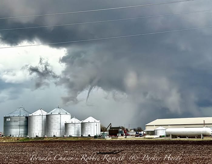
In a message to Local Corridor, storm chaser Robbie Russell said he saw the tornado at about 4:45 p.m. and that it was “visible for a solid minute before it got rain wrapped.” Russell said the images was taken by him and Parker Hardy, and both gave permission for Local Corridor to use the material with credit.
Russell said he and Hardy were working east of the damage path and did not personally witness emergency response activity afterward. Their images show a dramatic rotating storm structure over open farmland, along with a narrower tornado visible near farm buildings and grain bins east of the Iowa City area.
As of Thursday night, damage information was still developing. Broadcast and storm-report coverage indicated that at least some damage had been reported in the region as the storm continued east, but the full picture was still emerging. What was already clear by evening was that one of the day’s most closely watched storms had tracked from the Kalona area through southern Johnson County and then east of West Branch into Cedar County, producing multiple tornado reports and severe hail along the way.
Photo courtesy of Robbie Russell and Parker Hardy
https://www.kwqc.com/2026/04/02/first-alert-day-live-weather-blog/